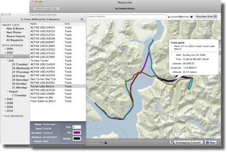
Track & Waypoint Browser
PhotoLinker provides a GPS track database and browser. Saved track files can be imported from the computer or downloaded directly from a GPS receiver. Tracks are automatically cataloged by date and displayed on an interactive map where the size and color can be adjusted. The track browser handles years of data and millions of track points.
Loading Tracks
You can load your GPX, TCX or NMEA log files by dragging them into PhotoLinker and dropping them onto the map or image browser. Tracks may need to be downloaded directly from some GPS receivers.
Zoom to Fit
By default PhotoLinker will automatically zoom the map to fit a recently added track. This behavior can be adjusted in PhotoLinker's Preferences under the Maps tab.
The magnifying glass icon in the Track & Waypoint Browser can be used to zoom the map to fit the current track selection.
Right-clicking (control-clicking) on a source list also provides and option to Zoom To Fit.
Organization
The track and waypoint browser automatically organizes your tracks.
- Smart Lists
- Near & Recent shows tracks recently imported tracks as well as tracks within 24 hours of any loaded photos.
- Near Photos shows tracks within 24 hours of any loaded photos.
- Recent Imports show the tracks most recently imported.
- All Waypoints shows all loaded waypoints.
- Date Browser automatically organizes the loaded tracks by date.
- File Browser lists the files that tracks originated from.
Styling
Tracks can by stylized by selecting a track and using the controls to edit the size, border color and fill color.
Removing Tracks
Tracks can be deleted by selecting a track and hitting delete. Entire lists or files can be deleted by right-clicking (control-clicking) on a source list.

